
In 1908, New York announced plans to relocate Sing Sing Prison to Bear Mountain. The state actually began work on the building after purchasing 740 acres of land in 1909. Enter Mary Averell Harriman (widow of Union Pacific president, E.H. Harriman). Mary proposed to the then Governor of New York, Charles Evans Hughes, that she would donate 10,000 acres of land and $1 million for the creation of a new state park, but only if the plans for the prison were abandoned. George W. Perkins, head of the newly formed Palisades Interstate Park Commission, raised another $1.5 million, thanks to dozens of wealthy contributors including John D. Rockefeller and J. Pierpont Morgan. The state accepted, and on October 29, 1910, New York was presented with the deed to the land and a check.
In 1912, Major William A. Welch was hired as the Chief Engineer. By 1913, Major Welch (later to be recognized as the father of the state park and the national park movement) began the construction of the road that would link Bear Mountain to Sloatsburg, known today as Seven Lakes Drive. Major Welch also served as the Chief Engineer/General Manager of the newly formed park from 1910 to 1940.
The park opened on July 5, 1913 bringing 22,000 visitors by steamboats alone that year. By 1914, an estimated 1 million people a year were visiting the park. Winter sports were added in 1928, in fact, by 1960, more ski jump competitions were held at Bear Mountain than any other area in the United States. Unfortunately, the ski jumps have been closed since the 1970's.
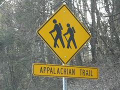
The first section of the Appalachian Trail, from Bear Mountain to the Delaware Water Gap, opened on October 7, 1923. The portion of the trail that passes through the Bear Mountain Zoo is the lowest point in the 2,170 mile hiking trail. Major Welch also served as the first chairman of the Appalachian Trail Conference. He is credited with designing the "A over T" marker that became the symbol of the Appalachian Trail.
On to our hike!
Beginning at the Bear Mountain Inn (will it ever reopen?), head west to reach the red-dot-on-white-blazed Major Welch Trail. The trail follows the shore of the Hessian Lake, offering a nice view of the lake. At the north end of the trail, bear left to ascend the northern slope of the mountain. The path inclines sharply and the rocky path becomes increasingly difficult as you climb. The footpath climbs a vertical distance of about 500 feet in roughly a quarter of a mile.
After climbing for what seems to be an eternity, the trail levels off to it's first panoramic view. Brooks Lake can be seen directly ahead with Bear Mountain Bridge and Anthony's Nose behind it to your right. Take a break, drink some water, eat some turkey jerky and take a lot of pictures.
Although you might feel like you are at the top of the world, you are not and it's time to continue onward! Leaving the false summit, continue to climb the steep ascent until you arrive at the stone wall and Perkins Drive.
Nope, not there yet! Turn left and follow the road, then turn right continuing on the trail through the mountain laurel. Once at the true top, the trail levels off to a gravel road leading through more laurels where it joins a paved road. From here, it is only a short walk to Perkins Memorial Tower (named after the first president of the Palisades Interstate Park Commission). Bring quarters to refill on fluids from the vending machines!
Continue past the tower to a scenic view. From here head back to the tower, but bear right at a large boulder. You will see a plaque honoring Joseph Bartha as Trails Chairman of the New York-New Jersey Trail Conference. To the left we pick up the Appalachian Trail, marked by a white vertical rectangle.
Bear right and descend the mountain passing an old water pipline resting on a rock embankment. After only a short distance, the trail crosses Scenic Drive. Continuing to descend, we cross Scenic Drive again.
About a half mile from the mountain summit, the trail will cross Scenic Drive for the third time. Here, it turns right and follows the road. At the dead end turnaround, bear to the right and follow the trail to the left as it leaves the road (the pavement is marked with "I-HR"). Pass through a pine grove, then the trail begins to descend more steeply (note: due to extensive use, this section of the trail is heavly eroded and poorly marked. The AT is under a massive relocation of this section, but not expected to be completed until about 2011).
Follow the Appalachian Trail for about another mile until it joins the yellow-blazed Suffern-Bear Mountain Trail. Both trails cross a stream and turn sharply right. Continue to follow the road, crossing behind the skating rink (to the right) and an abandoned ski jump (to the left), descending to reach the junction behind the Bear Mountain Inn where our adventure began.
Whew! Climbing 1,305 feet and back sure does wear a person out! But almost 10 miles and 3 hours and we're feeling great!
For directions to the park and more information: http://www.nysparks.state.ny.us/
or call (845) 786-2701


10 comments:
Feeling great, huh? Um, yeah... You could've warned me we'd be doing more climbing than hiking! Would've worn my knee brace! Well, your insurance is going to pay for my bionic replacement parts. And then I'm going to bionically kick your turkey-jerky ass!!! LOL.
settle down Jamie Sommers...remember turkey jerkey saved your life! I never said YOU were feeling great, just everyone else reading the blog, cyber-hiking. So...you up for it again???
If it's not raining/snowing/sleeting this weekend, yeah, I'm game. But an EASY trail this time, OK? And I'm bringing my *@#$% knee brace. And more tissues.
I suggest that next time peg leg aka tool blaze the trail for us...so then we don't have to listen to her whining as we forge Into the Wild....
Thanks for the shout out!! I am truly honored. The jacket looks pretty good, but it's probably not trail approved. We need to get together to start mapping out our AT adventure. I'm ready to tackle the big one whenever you are.
I am always ready to step Into the Wild...
Check out L&R trying to look all cool about the "AT adventure." I was whining, eh? I recall her saying that she felt like her heart was going to explode, after she scurried up to the first false summit... Anyway, NH, thanks for the photo credit. LOL.
Dear Tool,
You are cordially invited to embark on our AT Adventure. Just make sure you pack your knee brace and a muzzle....
Regards,
Law and Order
okay, ladies, please take it to email or over the phone....this is not the place. Thanks.
Post a Comment